The Madaba Map is a great mosaic floor representing the Christian cities of the Middle East before the islamization, a sort of picture of the area from Mediterranean to Arabic Desert, from Lebanon to Nile’s delta at the end of 6th century CE.
The land promised to Abraham, the space where the twelve tribes of Israel settled, represented in the mosaic of the Saint George Church in Madaba, Jordan is the object of an exhibition scheduled in Rome, in the seat of the Società Geografica Italiana, from February 22th to March 14th, 2024.
The exhibition aims to present the first results of the research activity carried out in Jordan since 2019, as part of a geographical and archaeological mission supported by the Italian Ministry of Foreign Affairs and Cooperation.
The acronym REMAP is intended to evoke the action of mapping through innovative technologies capable of adding content to the representation and offering a more engaging narrative. The mosaic tiles correspond to as many signs in the landscape, tangible and intangible, which need to be decoded to reconstruct interrupted or forgotten plots.
The exhibition “Tiles of Time” is organised in four sections preceded by an introductory section.
In the introductory section, the centrality of the mosaic map of Madaba is rendered through two large
panels: a reproduction of the mosaic from which it is possible to access multimedia content (augmented reality) through a web app, and a large map in which all the toponyms taken from the various sources analysed are geolocated, suggesting a possible reconstruction of the mosaic’s original extent.
ReMAP proposes the reconstruction of the historical landscape based on cartographic, documentary and archaeological sources analysed through a methodological approach capable of highlighting geographical and cultural nodes and paths and the use of innovative technologies for data management and sharing.
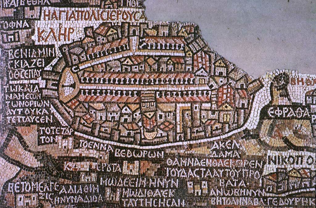
The object of the research, but we could better define it as the red thread that unites the various activities undertaken, is the Madaba Map (6th century BC), a detailed mosaic representation of the Holy Land, preserved in the Church of St. George in Madaba.
The first section, A Map for the Soul, is dedicated to this extraordinary representation, whose singularity, compared to contemporary mosaic works, lies in the clear intention to place the locations represented in a correct spatial relationship, considering the hydrographic and morphological components of the territory and the regional road network.
The mosaic visible today, which has survived the impact of time and men, occupies approximately thirty square metres, whereas it was originally intended to occupy more than ninety square metres.
Oriented with the east at the top, the mosaic map described a large region, from the Nile Delta to Lebanon and from the Arabian Desert to the Mediterranean Sea, which are the geographical limits of the land promised to Abraham. The subdivision of the territory among the twelve tribes of Israel, the presence of the patriarchal blessings for each tribe, the direct biblical references, and the centrality of Jerusalem suggest the theological character of the representation, even if this is not the only key to interpretation.
The large number of toponyms, the vignettes of cities easily recognizable thanks to identifying architectural elements, the many references to the physical characteristics of the area, rendered with pictorial realism, make it a sort of geographical atlas of the Near East from Lebanon to Egypt.
This is why the mosaic has become, one might say obviously, the platform for accessing the data collected and produced by the project.
The research was divided into three main phases that initially led to the deconstruction of the document using interpretative keys (tangible vs. intangible culture; biblical vs. geographical knowledge) with reference to different sources and the geographical, cultural and socio-economic context; to its recomposition using augmented reality technologies to create a dynamic archive, which allows the visual perception to be enriched through overlapping information, so as to better understand the document, its history, and the historical landscape represented; and finally, to the proposal for the reconstruction of the historical landscape, limited, for the time being, to a few significant places on the basis of information deduced from the various sources, from the field survey, always starting from the Madaba map, which portrays the geographical, cultural and physical characteristics of the territory with singular effectiveness.
The second section is dedicated to The Madaba Library.
The Map of Madaba, from the point of view of the evolution of cartographic techniques and geographical knowledge, represents a point of arrival. It summarises the cartographic knowhow of the Roman and Byzantine world, but it is also, of course, a starting point. It therefore makes sense to try to reconstruct the consistency of a hypothetical Library of Madaba, understood as the set of sources that artists could refer to, and to study the legacy that this type of representation left behind, influencing medieval cartography.
Therefore, various sources were analysed, cartographies and iconographies in particular, which can be
placed in a wide time span, from the 1st to the 13th century C.E., the comparison of which made it possible to identify stylistic influences; loans; legacies and to identify the sources most likely to be known, available and considered authoritative.
These include the works of Eusebius of Caesarea and in particular the Onomasticon, Flavius Josephus, the Notitia dignitatum et administrationum omnium tam civilium quam militarium, the Itinerarium Provinciarum Antonini Augusti; the Topography of Theodosius Ptolemy’s Geography and the cartographies contained in the Greek and Latin manuscript codices preserved in the Biblioteca Medicea Laurenziana in Florence; the Tabula Peutingeriana which, although produced for different purposes and using different techniques than the Madaba Map, is certainly an important source for the survey of cities and roads.
The contemporary mosaics of Ma’in, Umm ar Rasas, Amman, Jerash, Bostra were also studied, which could offer models of urban representations, scenes of daily life, animals and plants useful for imagining the parts of the mosaic modified by the iconoclasts or irretrievably lost (see Piccirillo M., The mosaics of Jordan, 1992).
Medieval cartographies of the Holy Land were studied, both originals and copies. From them, toponyms and information on places that played a political, religious and economic role in the period under consideration (1st to 13th century) were extracted.
The toponymic notations (over 500), together with the related documentation, images and content
produced by the project (orthophotos, 3D reconstructions, DTMs, renderings, …) were uploaded onto a digital platform created to acquire, manage, analyse and visualise information, documents and multimedia content, and which, in a way, constitutes a modern Library of Madaba.
The third section is intended to be a kind of Landscape Time Machine. It compares photographs taken of the same places at different times starting with the first shots taken in the 19th century; historical and current cartographies; travel narratives from the second half of the 18th century to the second half of the 20th century that show how not only landscapes, means of transport, lifestyles and destinations have changed over time, but also the perception of places. The documents studied come from the archives of the Italian Geographical Society, the Institute for the Orient and other public and private archives and cover a wide time span of over two centuries.
For the project, an extensive photographic campaign was conducted to document all the places depicted on the Madaba Map. Many of the places documented by historical photographs were also re-portrayed to fully capture the changes that have taken place.
The fourth section Mapping Time, Mapping Space displays the outputs of the REMAP project.
As part of the research, a challenging field survey was carried out using a drone and a topographic GPS.
Virtual tours have been created for fifteen sites of great archaeological interest from the north to the south of Jordan and allow not only a 360° exploration of the sites, but also add information (images of mosaics no longer in situ or covered; floor plans; reconstructions) so as to be useful not only to a remote visitor, but also to visitors on site. Both the 3D models and the virtual tours are accessible and navigable via the digital archive and webapp, which are further outputs of the project.
The narrative of the territory over time that develops through the four sections of the exhibition emphasises the nature of social creation in the continuous transformation of the landscape, adopting a holistic approach that refers to the entire territory, city and countryside, protected areas and degraded landscapes, places of everyday life and sites of exceptional beauty.
Renata Salvarani © All rights reserved